Resilient infrastructure, technologies, and strategies
Collaborative concepts for walkable cities, safe landscapes, sustainable mobility, and participatory design approaches are reliant on data analytics and multi-level modelling.

In the face of global environmental crises and pandemics, urbanised areas are under constant pressure to adapt. Changes in social trends and user behaviour become more frequent and are difficult to predict. Since this results in a noticeable impact on urban infrastructure, strategies for the sustainable and adaptable design of cities must therefore recognise diverse and dynamic influences.
The integration of mutual, cross-thematic interactions is becoming an essential planning task in urban development. At the decision-making and implementation levels, computer-aided design methods are required which can take into account a variety of additional information and data sources. In the Future Cities Laboratory (FCL) modules, innovative tools are being tested that allow the responsive, polymathic design of legitimate and resilient development paths for urbanised areas.
Simulating urban complexity
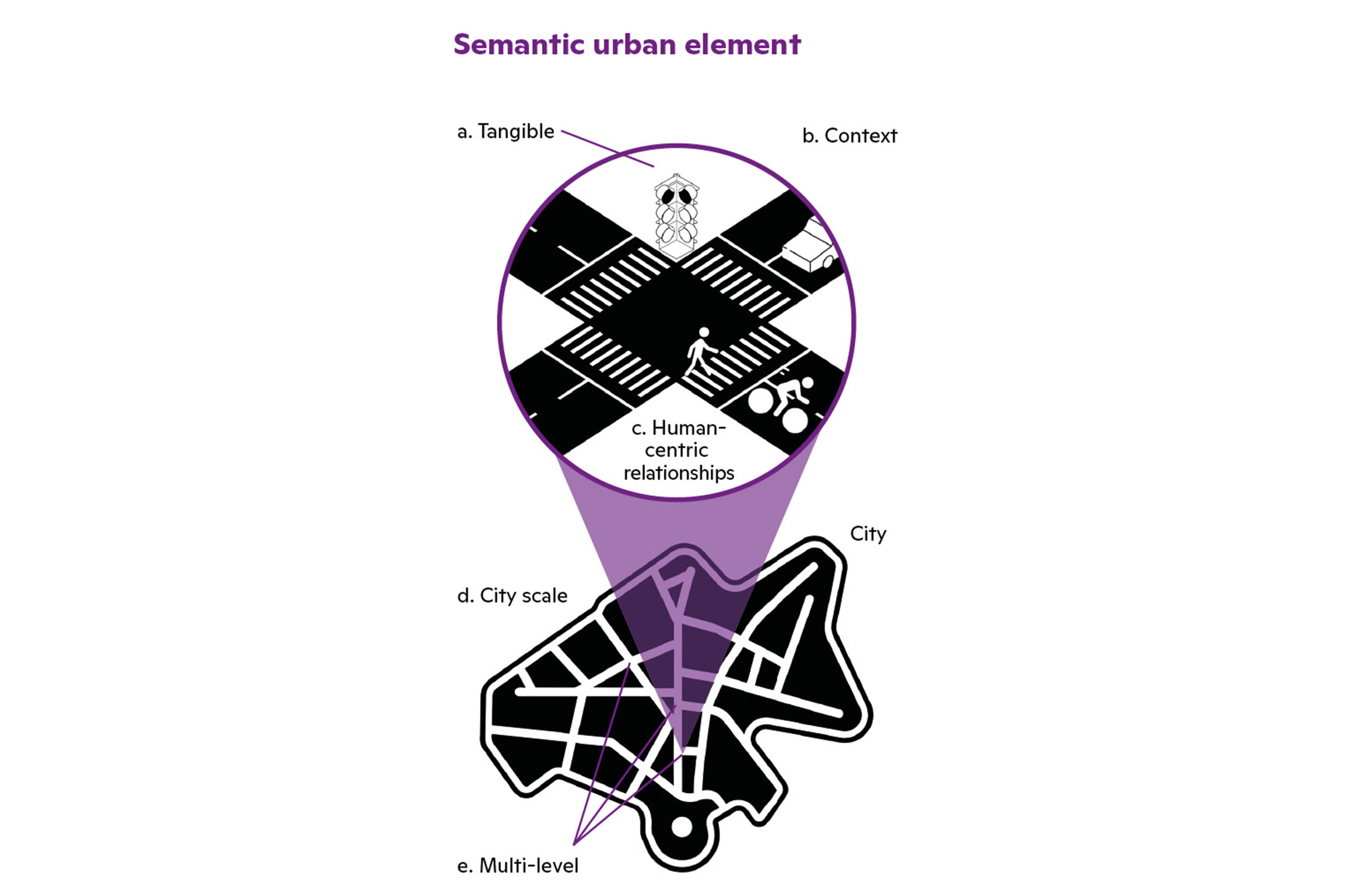
The module Semantic Urban Elements (SUE) makes complex urban entities and relations tangible for planners and designers. It simulates urban complexity with human-centred technologies to optimise the walkability in cities or evaluate multimodal shared streets. It extends technocratic data-driven processes for policy and city planning with a socio-technical approach for more user-recognised solutions in urban areas.
SUE defines a basic urban space that is digitally captured with various corresponding multi-level information. A main specialty of this method is to build bridges from evidence-based human perception to participative design solutions. Therefore, it is based mainly on data analytics to provide an urban search engine for designers and a tool for intervention and/or impact simulations.
Read more:
SUE
Semantic Urban Elements
Asst. Prof. Dr. Filip Biljecki
Prof. Dr. h.c. Dirk Helbing
AMI
Adaptive Mobility, Infrastructure, and Land Use
Asst. Prof. Dr. Prateek Bansal
Prof. Bryan T. Adey
RES
Resilient Blue-Green Infrastructures
Prof. Dr. Adrienne Grêt-Regamey
Assoc. Prof. Dr. Michiel van Breugel
Urban analytics is a central asset of SUE, based on an innovative use of human-generated sensing: street view imagery becomes a better source of data than sensors. It allows a crowdsourcing of billions of visual features worldwide that represent individual information about the urban environment and human activity in cities, e.g. from the perspective of pedestrians, cyclists, or car drivers.
FCL, in collaboration with the National University of Singapore, has released a street view image dataset of Zurich, Singapore, and over 650 other cities worldwide. It contains more than ten million images and 340 contextual and spatio-temporal features and can serve as an urban knowledge library for specific design studies or perception analyses.
Sustainable and adaptive mobility
The quality of transport systems is subjectively judged by users according to the current situation. Traffic jams, train delays, overcrowded trams at rush hour, or a lack of electric vehicle charging points are among the most common complaints. A more objective assessment is based on dynamic interactions: the needs of stakeholders change, and the continually modified infrastructure is sometimes adapted later than expected.
Therefore, owners, operators, or providers need better tools to plan an adaptive transport system. The module Adaptive Mobility, Infrastructure, and Land Use (AMI) addresses this issue by investigating how transport infrastructure planning processes can be improved to meet societal needs or to anticipate economic and environmental impacts.
The research aims to develop responsive infrastructure planning and the implementation of resilient transport systems. AMI has for the first time modelled the Swiss transport infrastructure planning process, critically assessing its ability to meet societal needs and proposing improvements. Advanced planning methods are also being used in exemplary ways to support the roll-out of electric charging infrastructure in Singapore and the extension of tram lines in metropolitan areas in Switzerland.
Design: collaborating with stakeholders
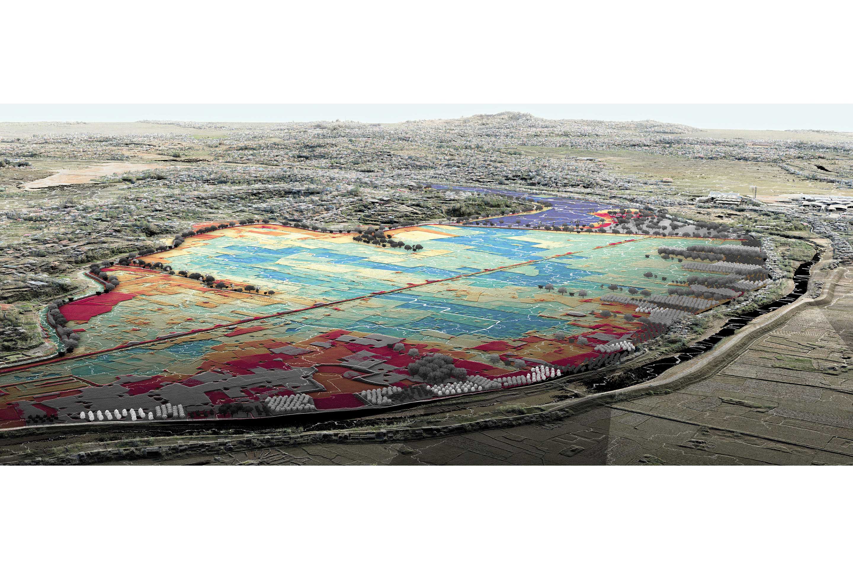
Adapting to climate change requires cities and urbanised areas to weave resilient structures into their future design. In order to mitigate flood risks while strengthening food security, this transformation must be based on socio-ecological inclusiveness. Therefore, the module Resilient Blue-Green Infrastructures (RES) focuses on a highly site-specific design approach that considers the physical terrain and soil as the primary infrastructure of urbanised landscapes.
The study site is the flood-prone capital city of Madagascar, Antananarivo. On site, landscape architects from the Department of Architecture at ETH Zurich conducted a design research studio, while researchers from Switzerland, Singapore, and Madagascar are documenting the site through large-scale surveys and three-dimensional modelling methods.
The paradigm shift towards inclusive urban design and spatial planning – also implemented by RES – enables a holistic vision for local adaptation: designers take into account the current land use and stakeholder needs. The qualities of communities and the peri-urban landscape are respected and even promoted by this design approach. RES shows that design is as important as engineering in enabling socially acceptable solutions.

